Cassone - SS. Benigno e Caro - S. Michele
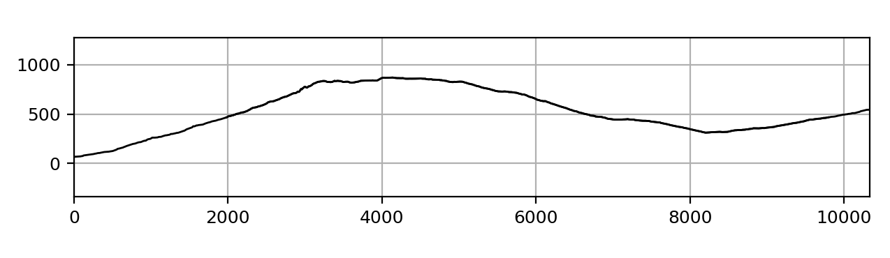
Starting point Cassone, Museum of the Lake, 66 m
Ending point Malcesine-Monte Baldo cableway intermediate station, 563 m
Difficulty E
Distance 10325m
Average slope 17%
Maximum slope 54%
Uphill \ descent difference in height 1242m\-762mm
Altitude min 66m
max 870m
Terrain types Asphalt road, footpath, paved mule track, dirt road

Non gettare rifiuti

Non raccogliere fiori

Scarpe specifiche
Scorta d'acqua e di cibo
Fondo dissestato
This splendid excursion, suitable for everyone but rather long and demanding due to the difference in height, allows us to cross the typical forms of erosion of the western side of Monte Baldo. Along this side, the rocky layers have a steep inclination towards the valley, often greater than the inclination of the slope, and form characteristic forms of erosion called “flatiron” or “irons”. The route begins at the Museo del Lago di Cassone, first on an asphalted road to the locality of Fichet and then on an old paved mule track (path no. 1), climbing up the shoulder of a characteristic “flatiron” structure. Along the path you first pass the Capitello della Merla (600 m), with a splendid view of the Vajo Il torrente, and then the Hermitage of SS. Benigno and Caro (800 m) with splendid views of Lake Garda. Along the climb you skirt the fortifications of the rear defense line set up by the Italians in the Great War. At an altitude of 830 the path n. 1 becomes a dirt road, proceeding northwards (always signposted n.1) and passing Porta del Vescovo. You reach the plateau of Malga Fiabio downhill (721 m); from here, follow the valley towards San Maggiore, always following the service road to the Malga (trail marker n.1). Arriving at the asphalted road, continue to the right up to the Campiano car park and from here take the road that soon leads to the intermediate station of the Malcesine – Monte Baldo cable car (parking).